Search This Blog

Showing posts with label Map. Show all posts

Friday, March 11, 2011

North Dakota Uranium Mines

Minerals:
URANINITE
Commodities:
URANIUM - U3O8 CONTENT
Data exported from DRC 2.0 (c) 2011 Gary Kindel

Ohio Mines with Fluorite and Fluorspar


Minerals:
FLUORITE
Commodities:
FLUORINE - FLUORSPAR


Data
exported from DRC 2.0 (c) 2011 Gary Kindel


Mines in Dodge County, Wisconsin


Minerals:
Commodities:
CALCIUM - None COPPER - None IRON - None LEAD - None SAND & GRAVEL - None STONE - LIMESTONE CB STONE - None


Data
exported from DRC 2.0 (c) 2011 Gary Kindel


Copper Mines in Wisconsin


Minerals:
Commodities:
COPPER - NATIVE COPPER - None COPPER - SULFIDE


Data
exported from DRC 2.0 (c) 2011 Gary Kindel


Sunday, January 3, 2010

Quartz Geode Location, near Elmville Highland County, Ohio

Colorless quartz crystals in cavities and geodes found in Lilley Dolomite formation along with calcite and sphalerite. Location in an abandoned quarry along the northside of Highway 54 approximately 1 mile west of Elmville. Locale is a short distance southwest of Dunkard Ridge Church along the Brusg Creek and Jackson Township boundary.
References:
  1. OGS Section no. 1296
  2. General Geology Bowman,R.S., 1956, Stratigraphic and paleotology of the Niagaran Series in Highland county, Ohio:Ohio State University PhD dissertation (unpublished) p133.
  3. Carlson, E, H, 1991, Minerals of Ohio: Bulletin 69: Ohio Dept of Natural Resources, Columbus Ohio, p.132

View Larger Map

Tuesday, August 18, 2009

Flint Collecting Near Flint Ridge Ohio

Flint Ridge area is roughly 3 miles SE of Newark, Licking County, Ohio and extends 12 miles to the Northwest up to Zanesville, Muskingum County, Ohio. Specifically near Brownsville Ohio at the location known as John Nethers farm. It is important to note, flint collecting is prohibited at Flint Ridge State Memorial and on state lands in the area. Flint collecting may be permissible on private lands but YOU MUST GAIN PERMISSION. This article DOES NOT grant permission. I visited this site numerous times between 1978-1984. Much of the flint deposits have been exhausted especially the "Nelly Blue" flint but drusy quartz can still be found. I found a large piece covered in good quality Smoky Quartz
View John Nethers Farm, Flint Ridge Ohio in a larger map
From Rocks
Ohio flint photo taken in Flint Ridge quarry pit near Toboso, Ohio
courtesy S. Cyd Read © www.naturalbornhikers.com (Flickr Photostream)

Sunday, June 28, 2009

Trip Report to Lodi Community Park, Lodi Ohio

On May 31, 2009, My family and went out to Lodi Community Park to hunt for Fossils.

Link to our second trip to Lodi Park
Link to our third trip to Lodi Park

Directions from Akron Ohio:

1)Take I-76 W/US-224 W toward Lodi Continue to follow US-224 W ~25 mi
2) Take the US-42/OH-421 ramp to Lodi/Medina 0.1 mi
3) Sharp left at Lafayette Rd/OH-421/US-42 Continue to follow OH-421 1.4 mi
4) Turn right at Elyria St/OH-83 0.2 mi

Map


View Larger Map

Once at the park, drive toward the back to the turn around and park along the road.
The collecting is along the river which is a tributary of the Black River. Fossils can be found in sandy shales and sandy limestone. Most of the sandstone fossils are just imprints. Fossil casts can be found in the shale and thin limestone beds.

While fossil collecting, we discovered some of the park's wild life:
small brown snake, several salamanders, toads, and crayfish.

While the fossil collecting cannot rated as great. It is a good location for young children and interesting fossils can be found. I would not drive out of my way for this location but if your in the Akron to Lodi to Cleveland Area, it does make for a nice outing.

Park has picnic and bathrooms. 1/4 mile further upstream from the end of the park is a nice wading pool in the river.


Tuesday, May 12, 2009

Fossil Collecting in Lodi, Medina County Ohio

Fossil Collecting in Ohio

Lodi City Park ( Medina County) permits collecting in Mississippian rocks (Meadville Shale).


View Larger Map

Thursday, January 1, 2009

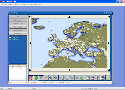
DRC Map showing mines in Europe

Here is a sample map created with Digital rockhounnd's companion showing mines in europe.


Steps to ceate this map are easy:
1) Click menu, select Map Builder
2) Click on the Available Layers tab.
3) Add the following map layers in order:
A) Select World BackGround Image and click insert button at bottom of screen.
B) Select Countries of the world Shape layer and click the insert button.
C) Select Mines outside North America Shape layer and click the insert insert button.
D) Click on the Map Tab and use the navigation arrow buttons and zoom buttons to include the area of interest. (Europe in this case).

My Adsense