Search This Blog

Tuesday, February 28, 2012

Gold Mines of Clermont County Ohio

Clermont County, Ohio has always had a little gold in the creeks. Over the years, fortune seekers have dug mines into the local hills searching for the vein of gold that would make them rich. They were wasting their time or should I say "Digging in vain."
The gold in this area was transporting in on the Illinoian glacier. It is alluvial or "placer" gold. The glacier's march southward ended here. The creeks will concentrate the gold in low areas or behind rocks in fast moving water.
There is not enough for a man to quit his day job. The real riches are just being in the creek on a beautiful fall day with a blue sky and autumn colors around.
These photos are part of the Ohio Department of Natural Resources "Geofacts No. 9" written in 1985. "Gold In Ohio"
www.dnr.state.oh.us/Portals/10/pdf/GeoFa cts/geof09.pdf

These photos have a strong local interest and have been in the public domain for some time.

Monday, February 27, 2012

Fossil Collecting near Falls of Ohio, Indiana & Kentucky

From Indiana DNR


The Falls of the Ohio is a great place to see fossils, but collecting is illegal except at the designatedcollecting piles next to the parking lot behind the Interpretive Center. There are other localities in the area where fossil collecting is permitted.
Please remember that collecting on private property always requires permission from the land owner. By listing these sites, we do not indicate that collecting is permitted without permission. These are some places that fossils have been reported in low to rich abundance. When in doubt - ask! Always be safe and courteous to those around you. There are many more locations, but as a courtesy to local collectors we cannot share them all!
Upper Ordovician (Maysvillian - Cincinnatian stages)

1.)
 U.S. 421 north of Madison, Jefferson Co., IN.
Type of exposure: Road cuts, also creek exposures on west side
Rock type: interbedded shale and limestone
Types of fossils: brachiopods, bryozoans, cephalopods, conodonts, corals, crinoids, edrioasteroids, gastropods, monoplacophorans, pelecypods, scolecodont teeth, sponges & stromatoporoids, starfish, trace fossils, and trilobites.
2.) State Road 155 between Fisherville (Jefferson Co.), KY and Taylorsville (Spencer Co.), KY
Type of exposure: Road cuts.
Rock type: interbedded shale and limestone in the Drakes and Grant Lake Formations
Types of fossils: brachiopods, bryozoans, cephalopods, conodonts, corals, gastropods, monoplacophorans, pelecypods, scolecodont teeth, stromatoporoids, trace fossils, trilobites. Mineralized brachiopods, aulocerid stromatoporoids and colonial corals with calcite, dolomite, celestine and other minerals.
3.) State Roads 467 and 227 between I-71 and Worthville, Carroll Co., KY.
Type of exposure: Road cuts
Rock type: Primarily shale with thin limestone layers in the Kope Formation
Types of fossils: brachiopods, bryozoans, cephalopods, conodonts, gastropods, graptolites, monoplacophorans, pelecypods, scolecodont teeth, trace fossils, trilobites.
4.) State Road 157 near Sligo (near rail road tracks)
Type of exposure: Road cut
Rock type: Rubbly limestone in the Grant Lake Formation
Types of fossils: brachiopods, bryozoans, cephalopods and gastropods. Mineralized brachiopods with calcite, dolomite and celestine.
These websites will help you identify your finds:

Lower Silurian
5.) State Road 329 at I-71 exit 14, south of the junction, north of Crestwood, Oldham Co., KY. Middle Silurian Laurel Dolostone above.
Rock type: Dolomitized limestone (Brassfield Formation)
Type of exposure: road cut.
Fossils: Not common. Minerals: calcite and minor barite has been noted.
Middle Silurian (Wenlock stage)

6.)
 State Road 245 between I-65 and Bardstown, Bullitt or Nelson Co., KY
Type of exposure: road cut
Rock type: Waldron Shale and Laurel Limestone (actually is a dolomitized limestone)
Types of fossils: brachiopods, crinoids, sponges, cephalopods, trace fossils, trilobites.
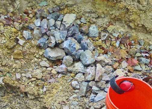
7.) Fossil collecting piles at the Falls of the Ohio State Park (when available at the rear of the parking lot)
Rock types: Waldron Shale; also Middle Devonian Jeffersonville Limestone (residual soil)
Type of exposure: Rock hauled in from area quarries
Type of fossils: brachiopods, bryozoans, cephalopods, corals, crinoids, cystoids, gastropods, graptolites, monoplacophorans, pelecypods, trace fossils, trilobites.
Middle Devonian (Eifel stage)

8.) Cannons Lane near Bowman Field airport (Louisville)
Rock type: Jeffersonville Limestone
Type of exposure: Road cut
Types of fossils: brachiopods, corals, and stromatoporoids
Also see (6, above) Jeffersonville Limestone
Type of fossils: brachiopods, bryozoans, corals, gastropods, pelecypods, trilobites.
9.) Port Road (beyond the terminus of I-265, north of New Middle Road),
Rock type: Jeffersonville Limestone
Type of exposure: Road cut, north bound lanes only.
Types of fossils: brachiopods, corals, and stromatoporoids in limestone.
Visit our on-line fossil brochures for assistance in identifying Devonian fossils.
Middle Mississippian (Osagean and Meramecean stages)

10.) Brooks Hill Road, Bullitt Co., KY
Rock types: Siltstone and limestone
Type of exposure: Road cut
Types of fossil: Harrodsburg = Warsaw Formation - blastoids, brachiopods, bryozoans, corals, crinoids, echinoids; Muldraugh Formation - brachiopods, bryozoans, crinoids, trace fossils; Brodhead Formation- brachiopods, bryozoans, corals (horn), trace fossils;
Geodes are noted in the Muldraugh formation, containing quartz, calcite and rarely aragonite. Many are fluorescent / phosphorescent with an ultraviolet lamp.
11.) US 150, Floyds Knobs, Floyd Co., Indiana (just off I-64 at exit 119, Greenville - Paoli exit)
Rock types: Siltstone, Edwardsville & Ramp Creek Formations
Type of exposure: Road cut
Types of fossils: brachiopods, bryozoans, crinoids, trace fossils
Upper Mississippian (Chester stage)

12.) Intersection of I-64 and State Road 37 at exit 86, Crawford Co., Indiana. Famous locality.
Rock types: Sandstone, shale and limestone, Beech Creek limestone, Tar Springs Sandstone, Indian Springs Mbr. (productive layer), Haney limestone, Hardinsburg sandstone
Type of exposure: road cut
Types of fossils: blastoids, brachiopods, bryozoans, conularids, corals (horn), crinoids, gastropods, pelecypods, shark teeth and scales, trace fossils, trilobites.
The late Dr. Alan S. Horowitz (died, 1999), was the Curator of Paleontology at Indiana University after a career with Marathon Petroleum Co. His research interest was Chesterian fossils, especially bryozoans and blastoids. This article (PDF) from the MAPS Digest published in 1991 describes the Sulphur road cut, geology, paleo-ecology and the list of fossils found there.

13.) State Road 37 several miles north (near Grantsburg, Crawford Co., Indiana)
Rock types: Sandstone, shale and limestone
Type of exposure: Road cut
Types of fossils: blastoids, brachiopods, bryozoans, conularids, corals (horn), crinoids, gastropods, pelecypods, shark teeth and scales, trace fossils, trilobites.
Utilizing geological maps, old publications, and stopping were it is safe along road cuts, you will find there are many places in Indiana and Kentucky where fossils can be found.
We recommend using state highway maps and Louisville / Jefferson County road maps to find localities effectively or county road atlases for Indiana and Kentucky. Much fossil collecting is driving around and exploring outcrops. No collecting in municipal parks.

Sunday, February 19, 2012

Flint Collecting at Nethers Farm, Muskingum County, Ohio

The flint at the Nethers Farm is part of the  Vanport flint formation that is  Pennsylvanian in age and covers a ridge tops in an  area of about 6 square miles. The flint deposit ranges 1-12 feet thick. Flint Ridge flint is noted for its array of colors and suitability for lapidary and flint knapping. This flint was used various prehistoric peoples the Midwest.  Artifacts from this flint has been found across US from east coast to Missouri and north into Michigan.

Chert, flint and chalcedony are microcrystalline varieties of quartz. Chalcedony is the general term applied to fibrous varieties whereas flint and chert are granular varieties. Flint and chert resemble each other and there is no sharp distinction between them. However, dark, siliceous nodules, usually found in chalk, are called flint; whereas lighter colored bedded deposits are called chert. All three varieties of microcrystalline quartz exist on Flint Ridge.

The Nethers Farm is located at 3680 Flint Ridge Road, north of Hopewell, Ohio.


View Larger Map


Nethers Farm is located near the center of the flint deposit.  This site has long been open to "modern" rockhounds. For a mere $5.00 collecting fee, you can take home all the rock you can carry for only 50 cents per pound. All one needs to do to collect there is show up on any given day - advanced notice or a reservation is not necessary. The side porch is left open and the directions on how and where to collect and pay your fees are left hanging next to the inside door above a large scale.

When you're done collecting, you must visit the side porch to weigh your rocks, calculate your total fee ($5 plus 50-cents per pound of rock). The money is to be put in a furnished envelope and slipped under the inside door. If nobody is around to collect your fee, this works on the honor system, so be please be honorable should you decide to visit the Nethers Farm.

The two-track dirt road leading to the collecting area is directly across the street from the farm.

PLEASE NOTE: this post does not imply permission to collect flint at the Nethers Farm.  Please inquire before collecting!  This is rare that a collecting site has remained open to the public all these years. 

Two very good articles on the Vanport Flint at the Nethers Farm are:

Nethers Farm, Flint Ridge Rockhounding Muskingum County, Ohio 
September 27, 2010 by Mike Streeter (mcstreeter@charter.net)

Flint Ridge by James St. John,  OSU-Newark Geology


Photos from http://mcrocks.com/ftr10-1/StreeterSeptember2010.html


Tuesday, February 7, 2012

Gold Producing Vein Deposits in Tennessee

NameStateCountyLatLong
56 RowsData exported from DRC 3.00 (c) 2012 Gary Kindel
BOYD MINETENNESSEEMONROE35.272222-84.234444
BRANNON PROSPECTTENNESSEEMONROE35.212778-84.348611
CALF YOKE ADITTENNESSEEMONROE35.262778-84.311389
CALICO TRENCHESTENNESSEEMONROE35.233889-84.313333
CLOSMAN WORKINGSTENNESSEEMONROE35.293333-84.234722
JOHNSON PROSPECT PITTENNESSEEMONROE35.285278-84.252778
LENDERMAN ADITTENNESSEEMONROE35.286944-84.254444
LENDERMAN PROSPECT PITTENNESSEEMONROE35.286667-84.254722
LONSDALE ADIT, NORTHEASTTENNESSEEMONROE35.229167-84.316111
LONSDALE ADIT, SOUTHWESTTENNESSEEMONROE35.228333-84.317222
LONSDALE TUNNEL, SOUTHEASTTENNESSEEMONROE35.228889-84.3175
LOWER MAGILL PROSPECTTENNESSEEMONROE35.291667-84.248889
LOWER PECK ADITTENNESSEEMONROE35.292222-84.248056
MCDONALD PROSPECTTENNESSEEPOLK35.181111-84.310833
MILLSAP ADITTENNESSEEMONROE35.264167-84.087778
PARIS ADITTENNESSEEMONROE35.244167-84.323889
PECK PROSPECTTENNESSEEMONROE35.292778-84.2475
PROSPECT PITTENNESSEEMONROE35.2975-84.238056
PUMPHOUSE WORKINGSTENNESSEEMONROE35.267222-84.306667
ROBERTS BRANCH ADIT, SOUTHWESTTENNESSEEMONROE35.220278-84.323611
ROUND TOP, LOWER ADITTENNESSEEMONROE35.296944-84.240833
ROUND TOP, NORTH WORKINGSTENNESSEEMONROE35.298611-84.239722
ROUND TOP, UPPER ADITTENNESSEEMONROE35.296667-84.240833
SIXMILE CREEK ADITTENNESSEEMONROE35.288056-84.239444
STRIPPED AREATENNESSEEMONROE35.264444-84.309444
UNNAMED ADITTENNESSEEMONROE35.218889-84.341389
UNNAMED ADITTENNESSEEMONROE35.236944-84.314444
UNNAMED ADITTENNESSEEMONROE35.236944-84.315278
UNNAMED ADITTENNESSEEMONROE35.249167-84.298056
UNNAMED ADITTENNESSEEMONROE35.258611-84.308056
UNNAMED ADITTENNESSEEMONROE35.268056-84.308056
UNNAMED PROSPECTTENNESSEEMONROE35.225833-84.337778
UNNAMED PROSPECTTENNESSEEMONROE35.227222-84.315833
UNNAMED PROSPECTTENNESSEEMONROE35.228889-84.319722
UNNAMED PROSPECTTENNESSEEMONROE35.238056-84.317222
UNNAMED PROSPECTTENNESSEEMONROE35.255556-84.306111
UNNAMED PROSPECTTENNESSEEMONROE35.285-84.246667
UNNAMED PROSPECTTENNESSEEMONROE35.283611-84.251389
UNNAMED PROSPECTTENNESSEEMONROE35.291389-84.249444
UNNAMED PROSPECTTENNESSEEMONROE35.295278-84.242222
UNNAMED PROSPECT PITTENNESSEEMONROE35.2375-84.316389
UNNAMED PROSPECT PITTENNESSEEMONROE35.247778-84.299722
UNNAMED PROSPECT PITTENNESSEEMONROE35.258056-84.303611
UNNAMED PROSPECT PITTENNESSEEMONROE35.264444-84.323889
UNNAMED PROSPECT PITTENNESSEEMONROE35.261111-84.246944
UNNAMED PROSPECT PITTENNESSEEMONROE35.283056-84.252778
UNNAMED PROSPECT PITTENNESSEEMONROE35.287778-84.252222
UNNAMED PROSPECT PITTENNESSEEMONROE35.288889-84.2525
UNNAMED PROSPECT PITSTENNESSEEMONROE35.284444-84.253889
UNNAMED PROSPECT PITSTENNESSEEMONROE35.288611-84.255556
UNNAMED PROSPECT PITSTENNESSEEMONROE35.289444-84.255833
UNNAMED PROSPECTSTENNESSEEMONROE35.281111-84.290833
UNNAMED SHAFTTENNESSEEMONROE35.237222-84.316111
UPPER JOHNSON ADITTENNESSEEMONROE35.285556-84.2525
UPPER MAGILL PROSPECTTENNESSEEMONROE35.291944-84.248611
UPPER PECK ADITTENNESSEEMONROE35.292778-84.248056

Placer Gold Deposits in Tennessee

NameStateCountyLatLong
19 RowsData exported from DRC 3.00 (c) 2012 Gary Kindel
ALVIN BRANCH PLACER WORKINGSTENNESSEEMONROE35.249167-84.325278
ANNETTE PLACER WORKINGSTENNESSEEMONROE35.252222-84.301389
BIG BRANCH PLACER WORKINGSTENNESSEEMONROE35.269167-84.261667
BIG SURFACE WORKINGSTENNESSEEMONROE35.264167-84.260556
BOYD PLACER WORKINGSTENNESSEEMONROE35.275556-84.249444
COOPER MINETENNESSEEMONROE35.233611-84.315
EL TIGRE MINETENNESSEEMONROE35.26-84.249722
EL TIGRE PLACERTENNESSEEMONROE35.213889-84.346389
GEAR PLACER WORKINGSTENNESSEEMONROE35.268333-84.256944
HOLLINGHEAD FIELD PLACERTENNESSEEMONROE35.249444-84.287222
HOTWATER BRANCH PLACERS WORKINGSTENNESSEEMONROE35.254444-84.306944
JOHNSON BRANCH PLACER WORKINGSTENNESSEEMONROE35.268056-84.271389
LOST RIVER MINETENNESSEEMONROE35.267778-84.260278
MCALLISTER BRANCH PLACERTENNESSEEMONROE35.259444-84.275556
MILL BRANCH PLACER WORKINGSTENNESSEEMONROE35.212778-84.339444
UNNAMED ADITTENNESSEEMONROE35.268056-84.308056
UNNAMED PROSPECT PITTENNESSEEMONROE35.250278-84.301944
UNNAMED PROSPECT PITTENNESSEEMONROE35.2625-84.263611
WHIPPOORWILL BRANCH PLACER WORKINGSTENNESSEEMONROE35.291389-84.238889

My Adsense